Modificatory authorisation and interior rehabilitation plan «Mas del Rosari» sector. Paterna
Arquitecto/Architect:
Mª Jesús Rodríguez
Mención COACV 2001-2002/2002-2001 COACV Mention
Figuras del planeamiento urbanístico/Town planning features
| Homologación modificativa y plan de
reforma interior. Sector «Mas del Rosari». Paterna Modificatory authorisation and interior rehabilitation plan «Mas del Rosari» sector. Paterna |
|
|
|
Arquitecto/Architect: Mª Jesús Rodríguez |
 |
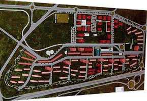
| DIRECTRICES DE LA ORDENACION El objetivo principal es la recualificación del sector mediante la inclusión de un nuevo tejido que regenerando el área, permita agotar el techo edificable construyendo viviendas que puedan ser calificadas como VPO, cumpliendo asimismo los objetivos fijados por el PGOU. |
PLANNING GUIDELINES The main aim is to upgrade the sector by introducing a new fabric to regenerate the area and enable the building density ceiling to be used to the full by constructing housing that may qualify for VPO [subsidised housing] while fulfilling the objectives established by the General Plan. |
|
|
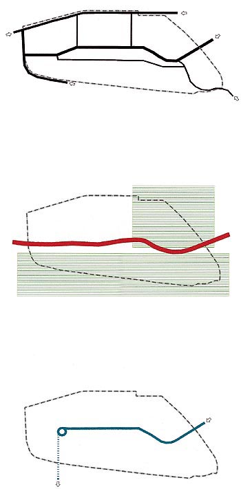
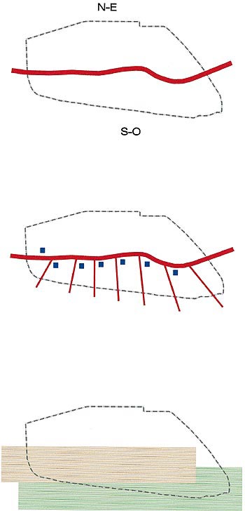
| CAMBIOS DE ESTRUCTURA FORMAL Prolongación de las vías de tráfico principales eliminando quiebros y discontinuidades, y clarificando la estructura viaria mediante la jerarquización de la misma. CHANGES IN FORMAL STRUCURE Prolongation of the main streets, removing turns and discontinuities and clarifying the road structure by establishing a hierarchy. Introducción del Tranvía, prolongando la vía existente hasta TVV a través del Campus de la Universidad, constituyéndose en vertebración de la actuación, pues se convierte en eje de unión entre la zona residencial existente y la de nueva creación. |
CHANGES IN FORMAL STRUCURE Prolongation of the main streets, removing turns and discontinuities and clarifying the road structure by establishing a hierarchy. Grouping of the green areas into a perimeter strip that establishes a green buffer against fast transit routes. The extension of the green area means removing the existing road running parallel to the Ademuz dual carriageway. Introduction of the Tram line, extending the existing line to the TVV television station through the University campus. This constitutes the backbone of the plan, becoming an axis that connects the existing and new residential areas. |
 |
|
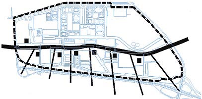
| CAMBIOS DE TIPOLOGIA DE LA EDIFICACION Concentración de vivienda plurifamiliar en torno a la vía de tráfico principal, definiendo de una zona longitudinal destinada a la construcción de viviendas en bloque con 5 plantas y profundidades entre 12 y 15 metros, que se desarrolla paralelamente al vial longitudinal secundario, estructurando la ordenación en dos sectores diferenciados N.E. y S.O. Definición de macroparcelas de tipología mixta en el Sector S.O., donde se conjuga la vivienda unifamiliar y plurifamiliar, propiciando el desarrollo de conjuntos residenciales con dotaciones privadas comunes. La introducción de zonas destinadas a torres de 13 plantas en estas macroparcelas cubre 2 intereses ; por una parte el establecimiento de unos hitos en altura que desde la autovía haga inteligible la estructuración del Sector, y por otra, satisfacer la necesidad de construcción de un mayor número de viviendas para rentabilizar la actuación. Las zonas reservadas a torres se ubican en el extremo Norte de las macroparcelas por razones de soleamiento. La eliminación del vial perimetral S-O además de permitir la ampliación de las zonas verdes se ha realizado para propiciar la fusión de las zonas de viviendas unifamiliar con las zonas verdes. |
CHANGES IN BUILDING TYPE Multiple housing concentrated along the main street, defining a longitudinal zone for the construction of 5-storey blocks of flats, 12 to 15 metres deep, running parallel to the secondary longitudinal street and structuring the layout into two differentiated sectors, NE and SW. Definition of mixed typology macro-plots in the SW sector, with single dwellings and multiple housing, favouring the development of residential groupings with shared private facilities. Areas of 13-storey blocks are sited in these macro-plots for two reasons: to establish high landmarks that will make the structure of the Sector intelligible from the dual carriageway and to meet the need to build a greater number of housing units to achieve a return on the outlay. The areas set aside for high-rise blocks are located on the northern edge of the macro-plots to make the most of the sunlight. The removal of the S-W perimeter road not only allows the green areas to be extended but is also conducive to the fusion of the single dwelling areas with the green areas. |
 |
|
|
|
![Ordenación según peri mas del rosari 93/Layout under 1993 'mas del rosari' peri [special interior rehabilitation plan]](120/12-120.jpg)
|
||