Seafront of the Albufera, Dehesa del Saler, sector. Valencia
Alfredo Fernández de la Reguera
Arquitectos / architects:
Ignacio Salvans
Jordi Solé
|
Ordenación
del frente litoral de la Albufereta sector Dehesa del Saler. Valencia Seafront of the Albufera, Dehesa del Saler, sector. Valencia |
|
|
Arquitecto
Director / architect, project leader: Alfredo Fernández de la Reguera Arquitectos / architects: Ignacio Salvans Jordi Solé |
|
|
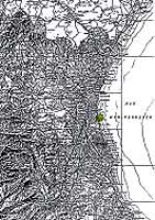
La Dehesa de El Saler es la formación natural marino-litoral que separa
la Albufera de Valencia del mar. El ecosistema de la Buhâira, tan rico
como perseguido, es víctima del crecimiento urbano e industrial, tan
intenso como mal planificado. Los planes de desarrollo turístico de la
Dictadura iniciaron la urbanización de la restinga litoral del Lluent en
los años 60, con un programa de construcciones de bloques en primera
línea de más de un millón de m2. En el periodo democrático se aprobó
y delimitó el Parc Natural de L'Albufera, paralizándose así el proceso
de destrucción del medio natural por la urbanización. Pero parte del mal
ya estaba hecho: la playa entró en regresión erosiva, las dunas eólicas
fueron arrasadas, los humedales cegados, el marjal pisoteado, el pinar,
falto de protección, en fuerte retroceso; frente a ello, la traza inmensa
de la urbanización, el «aeropuerto» según los lugareños, era coronada
por un paseo marítimo que, en un gesto insólito, se elevaba sobre la
línea del horizonte ocultando el mar. Un auténtico desastre.
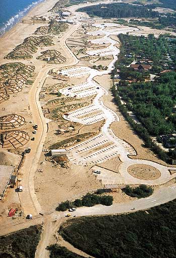
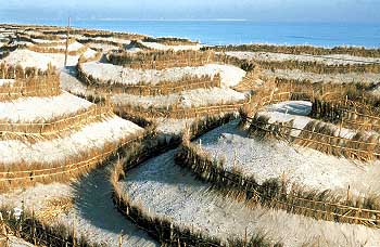
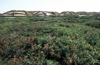
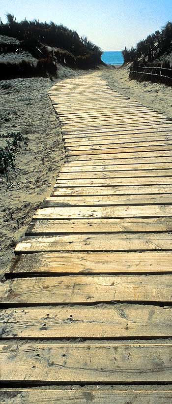
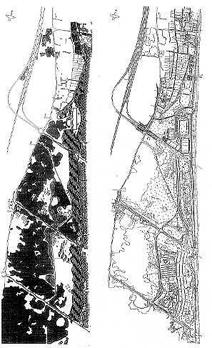
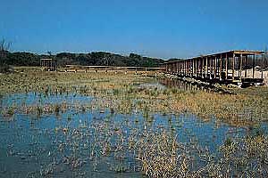
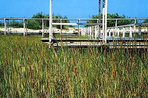
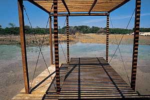
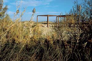
Había que empezar de nuevo. En primer lugar se trataba de restituir la sección territorial de su paisaje genético, unidad orgánica imprescindible por cuanto la degradación de una parte del ecotopo compromete la viabilidad del resto. Luego, rehacer ese paisaje tratando de compaginar las intervenciones naturalistas con los usos turísticos de la zona, sometida a la presión de la ciudad de Valencia y su área metropolitana, con más de un millón de usuarios potenciales. La autopista de El Saler y la carretera de Nazaret-Oliva, con enlaces a dos niveles, nutrían un territorio marginal en el que podíamos encontrar un Hipódromo y la Escuela de Estibadores abandonados, el Camping municipal, el complejo Polideportivo, un campo de golf y el Parador Nacional de Turismo. Primero fue la descontaminación general del sector de intervención. Cerca de 400 millones de pesetas fueron empleados en demoliciones para desmantelar la urbanización. Después proyectamos una estructura funcional superponible a la sección natural del territorio que íbamos a reconstruir. En ella, las vías de penetración, remodeladas, se transformaban en los cortafuegos del pinar y morían en los estacionamientos disuasorios. El litoral sólo se podía recorrer a pie. La restauración del "camí vell del Muntanyar", el carril de bicicletas Valencia-Sueca y el nuevo paseo que discurre por el trasdós del sistema dunar delantero, constituyen el sistema de relación del frente marítimo y proporcionan acceso a los equipamientos, ambientes lacustres y pasos controlados a la playa. Simultáneamente, teníamos que rehacer aquel paisaje. Sabíamos cuales eran los componentes del ecosistema, conocíamos las acciones dominantes, disponíamos de la información científica suministrada por la Oficina Técnica de la Albufera, sin embargo, cuál era, finalmente, la forma construida de esa naturaleza: ¿se trataba, acaso, de copiar imágenes de antiguas fotografías y viejos planos topográficos?, ¿imitar formaciones similares de otros lugares?; ¿ tal vez inventar un paraje aleatorio y pintoresco, terminado? Fue la Geometría, aquella que los griegos definieron como Ciencia del Conocimiento, quien nos proporcionó la respuesta: el dibujo riguroso del arrozal, el trazado regular de las acequias, la pulcritud de los campos roturados, el filtro de las arboledas, se adaptan perfectamente a la geografía de la plataforma aluvial. Sus deformaciones, debidas a los agentes atmosféricos, son mutaciones casuales que caracterizan los diferentes espacios del variado mosaico natural. Por otra parte, el resultado formal de la acción externa sobre el medio es visible en el propio microcosmos del territorio. Las ondulaciones y rugosidades que se perfilan, las huellas que se producen en los relieves, los colores y texturas, son los modelos auténticos que pueden transportarse a mayores escalas, a geometrías. Volúmenes, superficies y trazos definidos presuponen emplazamientos exactos, tipos, su medición, valoración y posibilidad constructiva. Diseñamos un módulo dunar básico, tipo Barchand, que maclado entre sí y orientado al viento dominante formaba la orografía ordenada de crestas y calderas, los "blow-outs" del sistema delantero y de los relieves subdunares. Una vez restituido el relieve dunar se procedió a su revegetación y fijación mediante el empleo de "bardisses" de caña y barrón, cuyos estratos contenían semillas de numerosas especies vegetales autóctonas, distribuidas según alturas y orientaciones del médano. El viento, la lluvia y las mareas se encargarían del resto. La masa arbórea, de pinus pinea y pinus halepensis, que deberá recuperar el ámbito interferido de la Pinada hasta alcanzar la orilla, se distribuye en una secuencia geométrica, desplazada formando "ripples" protectores contra la acción del Gargal. Los humedales de las "malladas", los espacios lacustres recuperados, son alternativamente lugares de cría de la avifauna y barreras limitadoras de penetración en el bosque. La extracción de materiales se practicó hasta la capa de limos grises impermeables (Tab), a excepción de algún sector, donde se perforó el nivel freático para conseguir una lámina de agua permanente. Una marquesina de madera, colinda con la sección del camino contiguo a la laguna; proporciona sombra y es el mirador sobre la Mallada. El paseo peatonal y el carril bici se sitúan a sotavento de la duna, en el lugar de menores aportes de arena, sobre la superficie hollada por las trazas de la anterior urbanización (en la proporción de 6 metros contra 80 metros). Los estacionamientos se camuflan tras las sinuosidades del conjunto subdunar, debiendo quedar integrados entre la futura arboleda, más las matas de lentisco, mirto, labiérnago y enebro marino que colonizan el suelo. El barco de hormigón rescatado del derribo de la Escuela de Estibadores, rehabilitado como Centro de información y documentación del Parc Natural, varado en las dunas nuevas, es en cierta medida la memoria de la intervención. Recuerda que la destrucción de la obra del hombre da paso a la construcción del paisaje inicial. Curiosa paradoja. |
La
Dehesa de El Saler is the natural seashore formation that separates the
Albufera of Valencia from the sea. The Buhâira eco-system, as rich as it
is endangered, has fallen victim to an urban and industrial growth which
is as intense as it is badly planned. The tourism development plans of the
Franco era began to develop the Lluent sandbar shore in the 1960s. Over a
million square metres of tower blocks lining the sea edge were planned.
Democracy brought the creation and delimitation of the Albufera Nature
Reserve and halted the urbanisation that was destroying the natural
environment. However, part of the damage had already been done. The beach
was starting to shrink due to erosion, the aeolian dunes were razed to the
ground, the wetlands had silted up, the marshes were trampled and the
pinewood, left unprotected, was shrinking fast, while the immense layout
of the development, known to the locals as the 'airport', had a crowning
touch: a seafront promenade which (unusually) rose above the line of the
horizon, hiding the sea from sight. All in all, a total disaster.A new
start was required, first restoring the generative cross-section of the
landscape in its organic unity, indispensable since the degradation of any
part of the ecotope endangers the viability of the rest, then recreating
the landscape, attempting to make the nature restoration operations
compatible with the leisure use of an area under pressure from over a
million potential users in the city of Valencia and its metropolitan area.
The El Saler motorway and Nazaret-Oliva main road, with junctions at two
levels, have nurtured a peripheral strip that includes the racecourse and
Stevedores School (both abandoned), the municipal campsite, the sports
complex, a golf course and the Parador hotel.
The first step was the general 'decontamination' of the sector covered by the project. Over 400 million pesetas were spent on demolishing the urbanisation works.The next was to design a functional structure that could be superimposed on the natural cross-section of the landscape to be reconstructed. The redesigned access routes became fire breaks for the pinewood and now end at dissuasory car parks. The length of the shoreline can only be covered on foot.The restored "old Muntanyar road", the Valencia-Sueca bicycle path and the new footpath to the rear of the frontal dune system constitute a network that connects up the shoreline, providing access to the facilities, the lake environments and the restricted pathways to the beach. At the same time, we had to remake the landscape. We knew the components of the ecosystem, we were aware of its main interactions, we had the scientific information provided by the Albufera Technical Office, but what form was this constructed nature to take? Should we copy what we saw in old photographs and topographical maps? Should we imitate similar formations from other places? Should we perhaps invent a fortuitous, picturesque beauty spot, ready-made?Geometry, which the ancient Greeks called the Science of Knowledge, provided the answer: the strict lines of the paddy fields, the regular layout of the irrigation canals, the cleanness of the ploughed fields and the filter of the groves are perfectly adapted to the geography of the alluvial shelf. Their deformations, due to atmospheric factors, are casual mutations that give the different spaces of the rich natural tapestry their character.Equally, the formal result of external factors that act on the medium is visible in the microcosms of the land. Undulations and outcrops, the lines on the elevations, colours and textures: these are the authentic models that can be transferred to a larger scale, to geometries. Volumes, surfaces and defined lines presuppose exact locations, types, the ability to measure, value and build. We designed a basic barchan-type dune module. Combined in a symmetrical chain, facing the prevailing wind, they form an orderly range of crests and hollows: the blow-outs of the frontal system and the sub-dunes. Once the line of dunes had been restored, they were planted and fixed with the help of cane 'hedges'. Their layers contained the seeds of numerous native plant species, distributed according to the face of the dune and their height on it. The wind, the rain and the tides would take care of the rest.The expanse of Pinus pinea and Pinus halapensis that will restore the missing area of the pinewood down to the shoreline was planted in a geometrical sequence, staggered in 'ripples' for protection against the Gargal wind. The wetlands of the malladas or grassy hollows, the recuperated lake spaces, are both breeding grounds for birds and barriers that limit access to the wood. They were dredged down to the impermeable grey silt loam (TaB) layer, except in certain areas where the water table was pierced to obtain a permanent sheet of water. A wooden canopy was placed alongside the section of the path that borders this lake, providing shade and a viewing point over the mallada.The footpath and bicycle path are placed in the lee of the dunes, where the least sand accumulates, along the route marked out by the demolished urbanisation works (but 6 rather than 80 metres wide). The car parks are camouflaged among the windings of the sub-dune system and should in time be integrated among the future trees and the lentisk, myrtle, phillyrea and 'sea juniper' (Juniperus macrocarpus) bushes that are colonising the ground.The concrete ship that was saved when the Stevedores School was demolished has been converted into a Nature Reserve Information and Documentation Centre. Beached among the new dunes, it is, in a way, a memorial to the project: a reminder that the destruction of the work of human hands makes way for the original landscape to be built. A curious paradox. |
|
Estudios previos de ordenación de la Conselleria d'Obres Públiques,
Urbanisme i Transports de la Generalitat Valenciana / Preliminary studies
by the Valencian Regional Government's Ministry of Public Works, Urbanism
and Transport: DIRECCIÓN DE OBRA PROJECT SUPERVISION ARQUITECTOS: / ARCHITECTS Alfredo Fernández de la Reguera Ignacio Salvans Jordi Solé Conselleria d'Obres Publiques, Urbanisme i Transports. Generalitat Valenciana / Ministry of Public Works, Urbanism and Transport, Valencian Regional Government :Ignacio Gil, Jefe del Servicio de Costas / Head of the Coasts Service Francisco Solves, Jefe Sección de Ordenación Litoral / Head of the Coastal Planning Section Oficina Técnica de la Devesa de la Albufera. Ayuntamiento de Valencia / Devesa de la Albufera Technical Office, Valencia City Ouncil :Antonio Vizcaino, biólogo, Jefe Oficina Técnica / biologist, Head of the Technical Office Control de Calidad / Quality control: Contratista / Contractor: |
 |
|