Marc Bigarnet & Frédéric Bonnet
| Parque
de la Ereta, Alicante
|
Ereta park, Alicante | |
| Arquitecto/Architect: Marc Bigarnet & Frédéric Bonnet |
|
| Recuperar
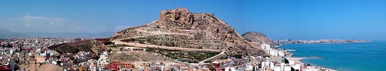
el icono de la ciudad El monte Benacantil domina el casco histórico, el puerto y el mar. Las poderosas fortificaciones habían conferido a esta zona militar un estado de abandono. Permanecía la imponente masa del monte, naturaleza tectónica, icono de la ciudad. La realización del parque supone una recuperación de este hito geográfico. En 1994, a raíz del concurso Europan 3, la Comunidad Valenciana y el Ayuntamiento de Alicante nos confiaron la realización de un parque urbano. La pendiente, los desprendimientos, la orientación sudoeste y el difícil acceso habían degradado poco a poco el lugar: imaginar aquí un jardín parecía un desafío casi disparatado. La integración de este espacio natural en los usos de la ciudad permite recuperar los vínculos entre los barrios degradados y la animación del centro urbano y del puerto, revitalizar las partes altas del casco histórico, rememorar la unión natural con el castillo, frente al mar. Esta reconquista del lugar propuesto ofrecía también la posibilidad de generar agradables reencuentros con un territorio conocido, espectacular y magnífico. |
Reconquering the icon of a city Mount Benacantil looks out over the old quarter, the port and the sea. Its strong fortifications had led to this area falling into abandon, like a heart outside the walls. There remained the imposing mass of the rock, tectonic nature, an icon of the city. The park is a recuperation of this geographical landmark. In 1994, following the Europan 3 competition, the Valencian regional government and Alicante city council commissioned us to create an urban park. Its steepness, fallen rocks, south-west orientation and difficult access had gradually deteriorated the site. It seemed an almost unreasonable challenge to imagine a garden there. Reintegrating this natural space into the habits of the city makes it possible to rediscover the links between the impoverished districts and the bustle of the city centre and the port, revitalise the higher areas of the old city and retrace its natural link with the fortress, facing the sea. This reconquest of a place offered as a legacy also provided happy reencounters with a spectacular, magnificent shared territory. |
   |
Emplazamiento / Location: Emplazamiento/Site: Alicante Cliente/Client: Generalitat
Valenciana, Dirección
de Urbanismo, Transportes y Obras Públicas Arquitecto Direccion de
Obras/Services
supervison architect: Arquitecto colaborador/Collaborating architect: Empresa Constructura/Contractor: Aparejador/Surveyor: Ingeniero agrónomo/Agricultural Engineer (planting
specification): Fotografías/Photographs: |
| Tres
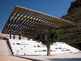
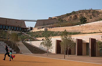
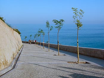
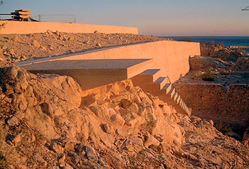
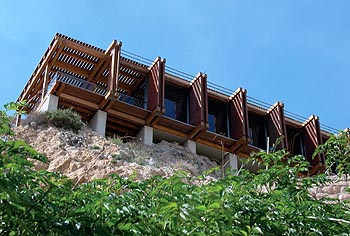
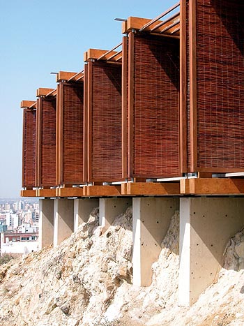
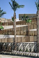
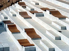
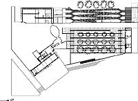
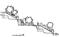
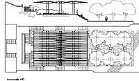
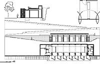
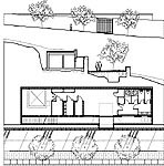
estrategias para un parque Una progresión de lo más urbano hacia lo más salvaje, ascendiendo por la colina: La parte baja del parque se halla en contacto directo con el casco histórico: aquí, el carácter de los lugares y de la vegetación es más urbano, más doméstico. Continuando hasta el castillo, el visitante atraviesa diferentes universos: La ladera de los olivos, que es una especie de 'campo en la ciudad', la plaza de la Ereta y los pinos, y después, la vegetación de carrasca local, y las gramíneas dispersas en la parte cercana a la escarpa. Sacar provecho de las exigencias técnicas para ofrecer un entorno accesible: La realización de muros de contención, de acequias para las aguas de escorrentía, de drenajes capaces de absorber las lluvias torrenciales era indispensable en este lugar tan frágil. Los elementos principales del parque están estrechamente ligados a estas importantes inversiones: el lindero es un camino que bordea la parte baja y asegura la recogida de las aguas pluviales; las terrazas de la ladera de los olivos estabilizan el suelo, limitan la erosión, y actúan como una enorme esponja cuando llueve intensamente... Enlazar diferentes escalas territoriales y arquitectónicas: Desaparecen las cesuras entre escala arquitectónica, urbana, paisajística o técnica. Simultáneamente, el terreno se convierte en muro de contención y después en fachada, los edificios —empotrados en el suelo— forman cuerpo con la colina y con su nueva estructura. |
Three strategies for a park Progression from the most urban to the wildest, climbing the hill: The bottom of the park is in direct contact with the old quarter. The character of the places and the vegetation is more urban, more domestic. Climbing towards the fort, visitors pass through different universes: the olive grove slope, a sort of ‘country in the city’, La Ereta square and the Aleppo pines, the local scrubland vegetation, then the scattered grasses beside the cliff. Make use of technical constraints to provide accessible places: Given the fragility of the site, it was essential to build retaining walls, rain water run-off channels and drains to cope with summer downpours. The two main places in the park are associated with these major investments: the edge is a path that borders the lower part and collects rainwater, while the terracing on the olive grove slope stabilises the soil, limits erosion and constitutes an enormous sponge for heavy rain. Interweave different geographical and architectural scales: Breaks between the architectural, urban, landscape and technical scales disappear. In a single movement the ground has become a retaining wall, then a façade; the buildings, set into the ground, are one with the hill and its new structure. |
   |
|
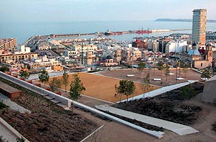
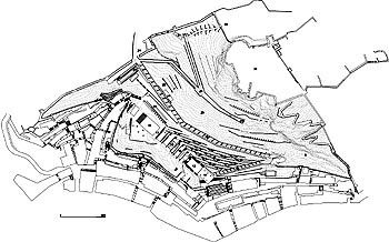
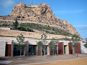
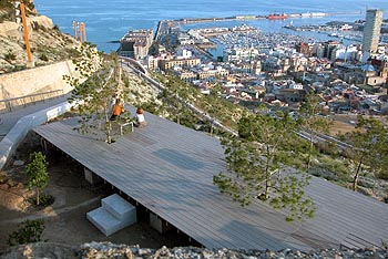
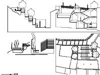
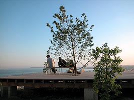
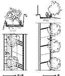
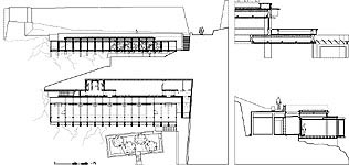
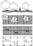
| Los
lugares del parque El parque organiza, en siete hectáreas, diferentes lugares, desde el más íntimo al más colectivo, desde el más salvaje —el monte en sí mismo— al más construido, desde el más limitado —los umbrales— al más amplio —la plaza de la Ereta abierta hacia el mar. —los
umbrales En el proyecto se integran cinco edificios: —un
edificio polivalente que recae hacia la ciudad
|
The places in the park The different places laid out over the park’s seven hectares range from the most intimate to the most communal, from the wildest, the bare rock, to the most built-up, from the smallest, the thresholds, to the largest, La Ereta square, overlooking the sea. —entrances Five buildings are part of the project: —multi-purpose
building at the interface with the city
|
  |
 |
 |
 |
 |
|
 |
||||
 |
 |
 |
 |
|
 |
 |
|||
 |
  |